

Fortæl dine venner om denne vare:
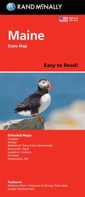
Virginia State Map, Rand McNally
Rand McNally

Virginia State Map, Rand McNally
Rand McNally
Rand McNally's folded map for Virginia is a must-have for anyone traveling in or through the state, offering unbeatable accuracy and reliability at a great price. Our trusted cartography shows all Interstate, U. S., state, and county highways and much more. Points of interest. State park chart. State mileage chart. Driving times map. On-the-road toolbox. Visitor center information. Climate data. State facts & symbols. Easy-to-use legend. Detailed indexed. Coverage Area: Detailed maps include, Alexandria/Arlington, Bristol, Charlottesville, Hampton Roads: Norfolk/Newport News/Virginia Beach, Lynchburg, Richmond/Petersburg, Roanoke, Shenandoah National Park, Washington, D. C. & Vicinity, Williamsburg/Colonial National Historic Park.
| Medie | Bøger Hardcover bog (Bog med hård ryg og stift omslag) |
| Udgivet | 22. september 2021 |
| ISBN13 | 9780528025143 |
| Forlag | Rand McNally |
| Genre | Maps & Guides |
| Mål | 500 g (Estimeret vægt) |
| Sprog | Engelsk |
Mere med Rand McNally


Andre har også købt
![Cover for Preben Hansen · Turen Går Til: Turen går til Californien & Vestlige USA (Hæftet bog) [5. udgave] (2021)](https://imusic.b-cdn.net/images/item/original/578/9788740063578.jpg?preben-hansen-2021-turen-gaar-til-turen-gaar-til-californien-vestlige-usa-haeftet-bog&class=scaled&v=1623395637)
![Cover for J. K. Rowling · Harry Potter: Harry Potter 6 - Harry Potter og Halvblodsprinsen (Indbundet Bog) [5. udgave] (2015)](https://imusic.b-cdn.net/images/item/original/277/9788702173277.jpg?j-k-rowling-2015-harry-potter-harry-potter-6-harry-potter-og-halvblodsprinsen-indbundet-bog&class=scaled&v=1441302687)
![Cover for Olga Ravn · De ansatte (Hæftet bog) [1. udgave] (2018)](https://imusic.b-cdn.net/images/item/original/583/9788702265583.jpg?olga-ravn-2018-de-ansatte-haeftet-bog&class=scaled&v=1521711504)
![Cover for Paludans Bilatlas over Europa 2016 (Spiralbog) [1. udgave] (2016)](https://imusic.b-cdn.net/images/item/original/473/9788772307473.jpg?2016-paludans-bilatlas-over-europa-2016-spiralbog&class=scaled&v=1532297840)
![Cover for Betty Edwards · Drawing on the Right Side of the Brain: A Course in Enhancing Creativity and Artistic Confidence: definitive 4th edition (Hardcover bog) [Main edition] (2013)](https://imusic.b-cdn.net/images/item/original/778/9780285641778.jpg?betty-edwards-2013-drawing-on-the-right-side-of-the-brain-a-course-in-enhancing-creativity-and-artistic-confidence-definitive-4th-edition-hardcover-bog&class=scaled&v=1398870041)

![Cover for Kent Haruf · Eventide - Plainsong (Paperback Bog) [Main Market Ed. edition] (2013)](https://imusic.b-cdn.net/images/item/original/457/9781447240457.jpg?kent-haruf-2013-eventide-plainsong-paperback-bog&class=scaled&v=1396360108)


![Cover for Barbara Kingsolver · Demon Copperhead: Winner of the Women's Prize for Fiction (Paperback Bog) [Main - Re-issue edition] (2023)](https://imusic.b-cdn.net/images/item/original/483/9780571376483.jpg?barbara-kingsolver-2023-demon-copperhead-winner-of-the-women-s-prize-for-fiction-paperback-bog&class=scaled&v=1680172538)
![Cover for Disney · Carl Barks & Don Rosa Bind II (Hardcover bog) [1. udgave] (2020)](https://imusic.b-cdn.net/images/item/original/218/9788793840218.jpg?disney-2020-carl-barks-don-rosa-bind-ii-hardcover-bog&class=scaled&v=1596799987)
Se alt med Rand McNally ( f.eks. Paperback Bog , Kort , Hardcover bog , Bog og Spiralbog )