
Fortæl dine venner om denne vare:
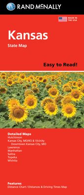
Rand McNally Easy to Read Folded Map: Kansas State Map
Rand Mcnally

Rand McNally Easy to Read Folded Map: Kansas State Map
Rand Mcnally
Rand McNally's Easy To Read State Folded Map is a must-have for anyone traveling in and around Kansas, offering unbeatable accuracy and reliability at a great price. Our trusted cartography shows all Interstate, U. S., state, and county highways, along with clearly indicated parks, points of interest, airports, county boundaries, and streets. The easy-to-use legend and detailed index make for quick and easy location of destinations. You'll see why Rand McNally folded maps have been the trusted standard for years. - Regularly updated, full-color maps. - 50% larger map with a bigger type size than the Rand McNally Folded Map. - Clearly labeled Interstate, U. S., state, and county highways. - Indications of parks, points of interest, airports, county boundaries, and more. - Mileage and driving times map. - Detailed index. - Convenient folded size. Coverage Area Detailed maps of: Hutchinson, Kansas City, MO/KS & Vicinity, Downtown Kansas City, MO; Lawrence, Manhattan, Salina, Topeka, Wichita. Product Details: Dimensions (unfolded): 28 x 40.
| Medie | Bøger Paperback Bog (Bog med blødt omslag og limet ryg) |
| Udgivet | 14. april 2022 |
| ISBN13 | 9780528025808 |
| Forlag | RAND MCNALLY |
| Mål | 250 g (Estimeret vægt) |
| Sprog | Engelsk |
Mere med Rand Mcnally


![Cover for Rand McNally · A Pocket Atlas of the [world] [cartographic Material]: Presented to the Patrons and Friends of the Chicago & North-Western Ry. Co. With the Compliments of the Passenger Department (Paperback Bog) (2021)](https://imusic.b-cdn.net/images/item/original/417/9781015179417.jpg?rand-mcnally-2021-a-pocket-atlas-of-the-world-cartographic-material-presented-to-the-patrons-and-friends-of-the-chicago-north-western-ry-co-with-the-compliments-of-the-passenger-department-paperback-bog&class=scaled&v=1649334010)


Andre har også købt
![Cover for Preben Hansen · Turen Går Til: Turen går til Californien & Vestlige USA (Hæftet bog) [5. udgave] (2021)](https://imusic.b-cdn.net/images/item/original/578/9788740063578.jpg?preben-hansen-2021-turen-gaar-til-turen-gaar-til-californien-vestlige-usa-haeftet-bog&class=scaled&v=1623395637)
![Cover for Lise Nørgaard · Kun en pige (Paperback Bog) [5. udgave] (2017)](https://imusic.b-cdn.net/images/item/original/831/9788702234831.jpg?lise-noergaard-2017-kun-en-pige-paperback-bog&class=scaled&v=1492430427)
![Cover for Asta Olivia Nordenhof · Serie B: Penge på lommen (Hæftet bog) [1. udgave] (2020)](https://imusic.b-cdn.net/images/item/original/713/9788793077713.jpg?asta-olivia-nordenhof-2020-serie-b-penge-paa-lommen-haeftet-bog&class=scaled&v=1578512342)
![Cover for Walt Disney · Carl Barks & Don Rosa Bind I (Hardcover bog) [1. udgave] (2020)](https://imusic.b-cdn.net/images/item/original/195/9788793840195.jpg?walt-disney-2020-carl-barks-don-rosa-bind-i-hardcover-bog&class=scaled&v=1583414842)


![Cover for Barry Holstun Lopez · Of Wolves and men (Paperback Bog) [Revised edition] (1979)](https://imusic.b-cdn.net/images/item/original/222/9780684163222.jpg?barry-holstun-lopez-1979-of-wolves-and-men-paperback-bog&class=scaled&v=1466361606)
![Cover for Lao Tsu · Tao Te Ching (Paperback Bog) [1st edition] (1989)](https://imusic.b-cdn.net/images/item/original/346/9780679724346.jpg?lao-tsu-1989-tao-te-ching-paperback-bog&class=scaled&v=1438694524)
![Cover for Rosamund Young · The Secret Life of Cows (Paperback Bog) [Main edition] (2018)](https://imusic.b-cdn.net/images/item/original/793/9780571345793.jpg?rosamund-young-2018-the-secret-life-of-cows-paperback-bog&class=scaled&v=1530148681)
![Cover for Karina Rasmussen · Hvalp i harmoni (Paperback Bog) [1. udgave] (2020)](https://imusic.b-cdn.net/images/item/original/516/9788799557516.jpg?karina-rasmussen-2020-hvalp-i-harmoni-paperback-bog&class=scaled&v=1585668935)
Se alt med Rand Mcnally ( f.eks. Paperback Bog , Kort , Hardcover bog , Bog og Spiralbog )